Trekking Maps of Nepal: Annapurna and Everest Routes Explained

 Amrit K. Aryal
Are you planning a trek in Nepal’s high Himalayas and wondering where to get trekking maps? If so, you are in the right place to read about it.
A Trekking Map can be your best companion, guiding you along hiking trails and highlighting elevation gains, landmarks, and the cultural and natural diversity of trekking routes. In this blog, we’ll explore two of the most iconic trekking trails in Nepal, the Annapurna Circuit Trek and the Everest Base Camp trek, through the lens of reliable trekking maps and break down the trekking routes.
Whether you’re an amateur trekker, a seasonal trekker, or preparing for your first trek in Nepal, knowing how to read and use trekking maps is essential to a safer, more enjoyable trek.
Trekking Map: The Best Trekking Tool
Trekking in Nepal is as thrilling as it is unpredictable. Online platforms like Awesome Holidays Nepal emphasize that while GPS devices are handy, they may not be available all the time, and are affected by cold, cloud cover, and technical errors, and may not work inside thick, dense forests.
It’s almost impossible to repair them if any hardware issues arise. In this case, a physical (or digital) paper map along with a compass can be your best companion on trails.
A Trekking Map indicated trail routes, altitudes, high passes, village names, campsites, water resources, teahouses, temples, bridges, rivers, roads, and much more. Nowadays, digital versions of the maps are also popular, with a zoom feature making them convenient to use on mobile phones.
Parts and Elements of a Trekking Map
A Trekking Map is a carefully crafted tool that brings clarity to the guides and trekkers across diverse trekking trails. To use it effectively, you need to understand some of its elements, such as pictures, lines, and symbols. By understanding these elements of a map, you can prepare better for trails like the Annapurna Circuit Trek or the Everest Base Camp Trek.
Title & Region:
A trekking map title leads you to the area you want to travel. For instance, “Panchpokhari Trekking Map” will tell you everything about the Panchpokhari and its trekking trails.
Scale:
The scale is the ratio between the distance on the map and the actual distance on the map, which relates to real-world distance. A 1:25,000 scale means 1 cm on the map equals 25,000 cm on the ground. Choosing a trekking map with a larger scale is better for higher accuracy.
Contour Lines
These curvy lines indicate the elevation. Each line has a unique height associated with it, and they never intersect each other. Close lines signify steep climbs, while wider gaps indicate gentler slopes. Understanding these Contour lines is vital for planning trekking and acclimatization.

Legends/Symbols
These are the icons representing trails, rivers, bridges, monasteries, villages, tea houses, campsites, and other physical features.
Grid & Coordinates
The intersected vertical and horizontal lines help to identify and locate the exact locations (latitude and longitude) of a place.
North Arrow
Always make sure that your compass is facing North and orient the map correctly with it for correct navigation.

How to Correctly Read a Trekking Map
Even the best Nepal trekking routes are frustrating if you don’t know how to read your map.
- Always align the north of your trekking map with the actual north.
- Plan your trek and note landmarks such as villages, rivers, tea houses, and resting points.
- Study elevation changes and contour lines to adapt to the elevation and adjust the oxygen level in the atmosphere.
- Reading contour lines helps trekkers understand when steep climbs appear along specific trekking routes.
- Compare landmarks like temples, rivers, monasteries, bridges, or suspension crossings on the map and test their accuracy.
- Use the scale to estimate how much to walk in a day. Remember, measuring on the map and walking in real terrain feels much longer and more difficult.
A quick view of Trekking Routes
Nepal is home to stunning trekking routes, from short, scenic treks to challenging high passes. There are at least a dozen treks, ranging from beginner-friendly to advanced.
- The Annapurna Region offers various side treks such as the Annapurna Circuit, the Annapurna Base Camp Trek, the Annapurna Sanctuary, Upper Mustang, and the Nar-Phu Valley.
- The Langtang Region offers trekking such as the Langtang Valley Trek, the Gosaikunda Trek, and the Tamang Heritage Trek.
- The Khumbu/Everest Region offers side treks like the Everest Base Camp Trek, Three Pass Trek, Khumbu Valley Trek, Makalu Base Camp Trek, Mera Peak Expedition, Island Peak Expedition, and Everest Base Camp Trek via Gokyo Lake.
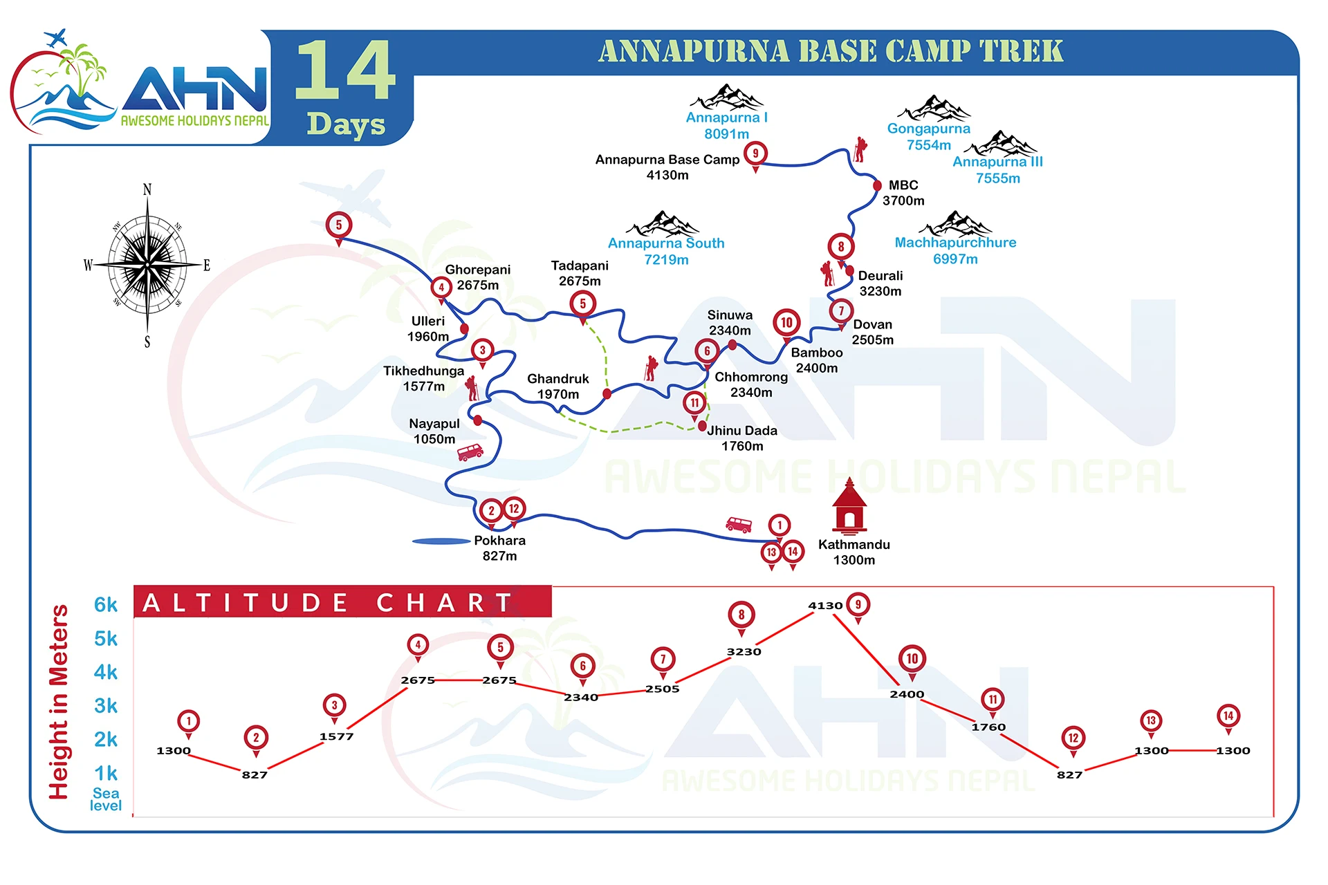
Trekking Map of Annapurna Circuit Route
Route
The Annapurna Circuit encircles the majestic Annapurna and its sisters. The Annapurna Circuit Trek is a round trip of 160–230 km, with the highest spot being the Thorong La Pass at 5,416 m.
The Annapurna Circuit Trek starts from Besisahar of Dhading and ends in the Kali Gandaki Valley. The Annapurna Circuit Trek features lush rhododendron forests, tropical woods, high arid terrain, and Tibetan-influenced villages such as Upper Mustang, Nar, and Phu.
Map
The Maps for the Annapurna Circuit Trek show elevation changes, high passes, streams, and trekking trails. This information is important for planning an itinerary, acclimatization days, and calculating pace. The map also consists of entry and exits of the conservation area, ticket counters that help trekkers to plan for the permits and entry tickets.
The map also consists of alternate routes to preserve the true trekking experience. Click this link to download the Map of the Annapurna Base Camp Trek.
Highlights
The Annapurna Classic Circuit Trek takes you through diverse landscapes, forests, rivers, and farm fields. The panoramic views of Annapurna I, Annapurna II, Annapurna III, Annapurna IV, Dhaulagiri, Machhapuchhre, Manaslu, Tilicho Peak, Mustang, and more are must-see observable spots.
Trekking Map & Route: Everest Base Camp
Route
The Everest Base Camp (EBC) Trek is another iconic route including Mount Everest. Trekkers start trekking from Lukla, and the trail follows the Dudh Kosi river, Namche Bazaar, Dingboche, Tengboche, Lobuche, and finally Gorak Shep. Most often, the itinerary includes climbing the Kala Patthar to observe Mount Everest.
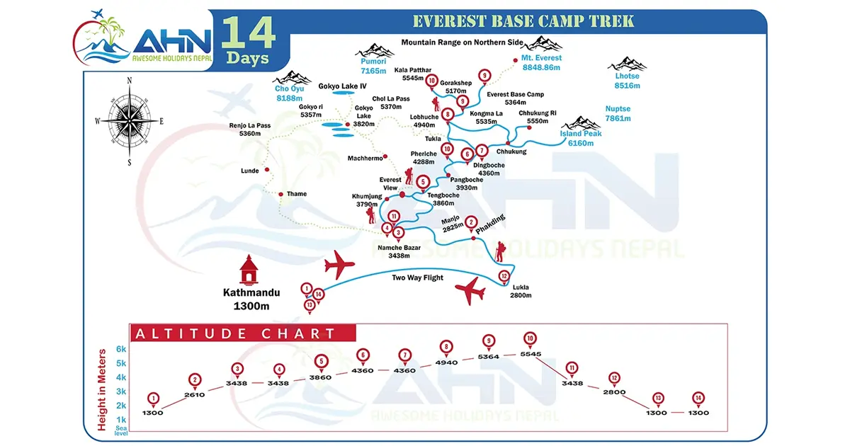
Map
The maps for the Everest Base Camp Trek include altitudes, resting points, and scenic detours like Gokyo Lakes, the three passes (Renjo La, Cho La, and Kongma La), or Island Peak.
Highlights
The Everest Base Camp Trek typically lasts 14 days, reaching up to 5,545 m above sea level. Key landmarks include Namche Bazaar, Tengboche, Gorak Shep, Kala Patthar, and Everest Base Camp. The best seasons for trekking to EBC are October–November and March–May, offering you stable weather and skies with clear views of the mountains.
5. Comparing Annapurna vs Everest Trekking Routes
| Feature | Annapurna Circuit | Everest Base Camp Trek |
| Length | 160–230 km; varied forests, passes | 70–80 km |
| Terrain | Forest, Bamboo Bushes | High alpine land to Glacial valleys |
| Difficulty | Moderate to difficult; | Moderate |
| Highest point | Thorung La Pass | Kala patthar |
| Map | Road impacts, elevation gain | Tea houses, altitude, contour lines, acclimatization |
| Scenery & Culture | Diverse ecology and rich Tibetan cultures of the Nubri and Thakali people | Buddhist monasteries, Chhortens, Sherpa villages, Khumbu region, and glaciers |
| Permits | TIMS, ACAP | Sagarmatha National Park Entry Permit, Khumbu Pasang Lhamu Rural Municipality Entry Permit, and TIMS card |
How to Choose the Right Trekking Map for Nepal
- Select maps that display alternative routes, rivers, tea houses, high passes, and entries/exits.
- Always carry a laminated paper map. Electronic GPS can sometimes run out of power, freeze in the cold or be out of reach.
- Make sure your next destination is marked on your map.
- Knowing how to read contour lines to find the elevation, indices, and symbols will help you navigate and pace more easily.
![]()
Tips for Navigating Nepal Trekking Routes with Maps
- Study the map and note the height, villages, and overall distance of the next destination.
- Keep track of your altitude increase and keep in mind that acclimatization is crucial; walk gently and drink plenty of water.
- For better results and safety, compare paper maps with digital apps along with a compass.
- Be respectful to the local people, culture, and environment.
- Be a responsible trekker, do not litter, and follow eco-friendly trekking options.
Final Thoughts
One of the most fulfilling experiences you can have is trekking in the Himalayas, and the secret to a safe and fun walk is a trustworthy trekking map. A decent map aids in understanding the terrain, planning your days, and staying on course, whether you’re trekking the renowned Annapurna Circuit, making your way to Everest Base Camp, or exploring other trekking routes in Nepal.
The correct map helps you get connected to the trekking trail, landmarks, scenery, and the people. Your trek in Nepal will be more than just a trek if you are prepared and have the appropriate equipment.
FAQs
Expand AllWhere can I find a reliable trekking map of Nepal?
You can buy trekking maps at bookstores, map houses, and gear shops in Kathmandu or Pokhara. Popular publishers like Himalayan Map House and Nepal Map Publisher produce detailed trekking maps. You can also get the digital version on the internet.
What are the main trekking routes in Nepal?
Some of the best trekking routes in Nepal are the Annapurna Circuit Trek, Everest Base Camp Trek, Langtang Valley Trek, Upper Mustang Trek, and Manaslu Circuit Trek.
How do Annapurna and Everest trekking maps differ?
Annapurna Trek maps cover a wide loop with multiple entry points and changing terrain, along with various side treks. On the other side, Everest maps focus more on altitude, tea houses, and limited side treks such as the Gokyo Lakes and three pass trek.
Which trekking map is best for the Annapurna Circuit?
Choose a map that shows the Natural Annapurna Trekking Trails (NATT) side treks. Annapurna Circuit maps from Himalayan Map House are highly recommended with detailed trails.
Which trekking map is best for Everest Base Camp?
Find a map that highlights villages like Namche, Tengboche, and Gorak Shep, with clear altitude markings. If these maps include side routes to Gokyo Lakes, it will be more beneficial.
How detailed are Nepal trekking maps?
A good map must include contour lines, villages, tea houses, rivers, bridges, monasteries, and alternative trails. They need to be detailed enough to plan for each day’s walk and acclimatization.
Can I use GPS along with trekking maps in Nepal?
Yes, most of the trekkers use apps like Maps.me or GPX tracks and carry physical GPS devices. Since batteries can die soon in cold weather, carrying a printed trekking map is a reliable backup.
Are printed maps or digital maps better for trekking in Nepal?
Both types have advantages and disadvantages. Digital maps are handy for zooming and observing new features, but printed maps never run out of power. Carrying both types of maps is good for greater efficiency.
How accurate are the trekking maps for the Annapurna Circuit?
If you are using the latest edition of the trekking maps for the Annapurna Circuit, they are generally accurate.
How accurate are the trekking maps for Everest Base Camp?
The trekking route in the EBC is well established. Using the latest maps includes small paths or new tea houses along with the heights.
Can trekking maps help with altitude planning?
Yes. Contour lines allow you to read the altitude and let you see where major ascents happen. Planning for acclimatization becomes easier.
Which map shows the best trekking routes in Nepal?
Regional maps by Himalayan Map House or Nepal Map Publisher give a broad overview. For trekking, buy dedicated maps of the Annapurna Circuit Trek or Everest Base Camp Trek.
How do the Annapurna and Everest trek maps compare in difficulty?
The map for the Annapurna Circuit Trek shows a longer loop circuit with diverse terrain and extended routes, while Everest maps highlight a shorter but higher-altitude trek.
Are there official government trekking maps of Nepal?
Yes, but they include fewer details. So, trekkers prefer commercially published trekking maps that are easier to read and updated more often.
How do I read contour lines on Nepal trekking maps?
Contour lines are lines in the trekking maps. Close lines indicate steep climbs, and wide spacing in the lines means gentle slopes. This helps you prepare for uphill stretches like Thorung La Pass or the climb to Kala Patthar.
Can trekking maps help me plan daily itineraries?
Yes, By checking the distance between villages, you can plan where to stay, where to eat, and where to rest and stay overnight.
How do I choose the right map for my trek?
Always choose a region-specific map with clear details, updated routes, and a scale you can comfortably read.
Are maps updated with current trail conditions?
Good publishers update maps regularly. But do not completely rely on maps and always ask your guide or locals for recent changes in the trail.
How do trekking maps show villages and tea houses?
Indices are used in the map to locate various spots in a map. Villages are marked with small symbols or dots, often with names. Tea houses are usually listed where accommodation is common.
Do maps indicate rivers and bridges on the trail?
Yes, suspension bridges, rivers, streams, villages, and trails are shown with clear indications, which is useful when trekking in valleys.
Can I rely solely on maps for navigation?
Maps include a lot of information needed for trekking but combining them with local advice and GPS makes trekking safer. Do not completely rely on a map and always seek advice from a guide.
How do Annapurna and Everest maps show altitude changes?
Both maps use contour lines and altitude markers at passes, viewpoints, and teahouses. This helps trekkers to see how high they’ll be climbing each day.
Are there maps showing both the Annapurna and Everest treks together?
Yes, some large Nepal trekking maps show multiple regions at once, but they’re less detailed than trek-specific maps. Better use region-specific maps for accuracy.
Can maps help in emergency situations on the trail?
Yes. A good map can show the nearest village, road, pass, bridge, medical house, or exit route in case of illness or injury.
How do I use trekking maps to avoid crowded trails?
A perfectly crafted map can highlight side routes, alternate paths that can allow trekkers to choose alternate paths to avoid crowds during peak season.
Which maps are best for comparing Annapurna vs. Everest treks?
Each of the maps is crafted for a specific region, highlighting the trails, distances, altitude profiles, and villages in each region. This helps you decide which suits you better.
Are trekking maps useful for beginners?
Yes, trekking maps are useful for first-time trekkers as well as experienced trekkers. Maps allow them to use maps to understand daily progress, landmarks, and resting points and allow them to prepare for acclimatization.
How can maps enhance safety during treks?
Maps include information to help you know where resting spots, tea houses, bridges, and exit routes are. They also allow you to understand the distance between villages and plan for daily routines.
Where can I buy or download official trekking maps of Nepal?
You can purchase them in Thamel in Kathmandu or Lakeside in Pokhara. Digital maps are available online through Himalayan Map House or trekking apps.
Related blog posts
Discover a choice of tourist destinations loved by most of our visitors. Whether you're on a jungle safari to spot rare animals or walking through a world heritage site, these well-planned itineraries cover the major highlights of Nepal.


")