Guge Kingdom: History, Ruins, and Viewpoints in Kailash Mansarovar Yatra

 Amrit K. Aryal
About 200 km from Mount Kailah lies a ruin that was once the capital of the Guge Kingdom, a Tibetan kingdom. It was once a great Himalayan civilization, a home to 100,000 people, and was the largest developed city in Tibet. And one night, everyone just vanished without a trace. The houses, walls, and temples are still frozen in time. Nobody knows where the people are, as there is no evidence of battle or escape.
As we visit the lost kingdom of Guge, we raise many questions about the people’s disappearance. Whether it was an invasion, economic collapse, or any religious conflict, the mysteries are hidden somewhere.
Now all we can see are the ruins of the palaces, the discovery, and the underground escape. As pilgrims travel to the Kailash Mansarovar Yatra in 2026, let your itinerary include a Tsaparang Day Trip, where history and mystery quietly walk hand in hand.
Where is the Lost Guge Kingdom Located?
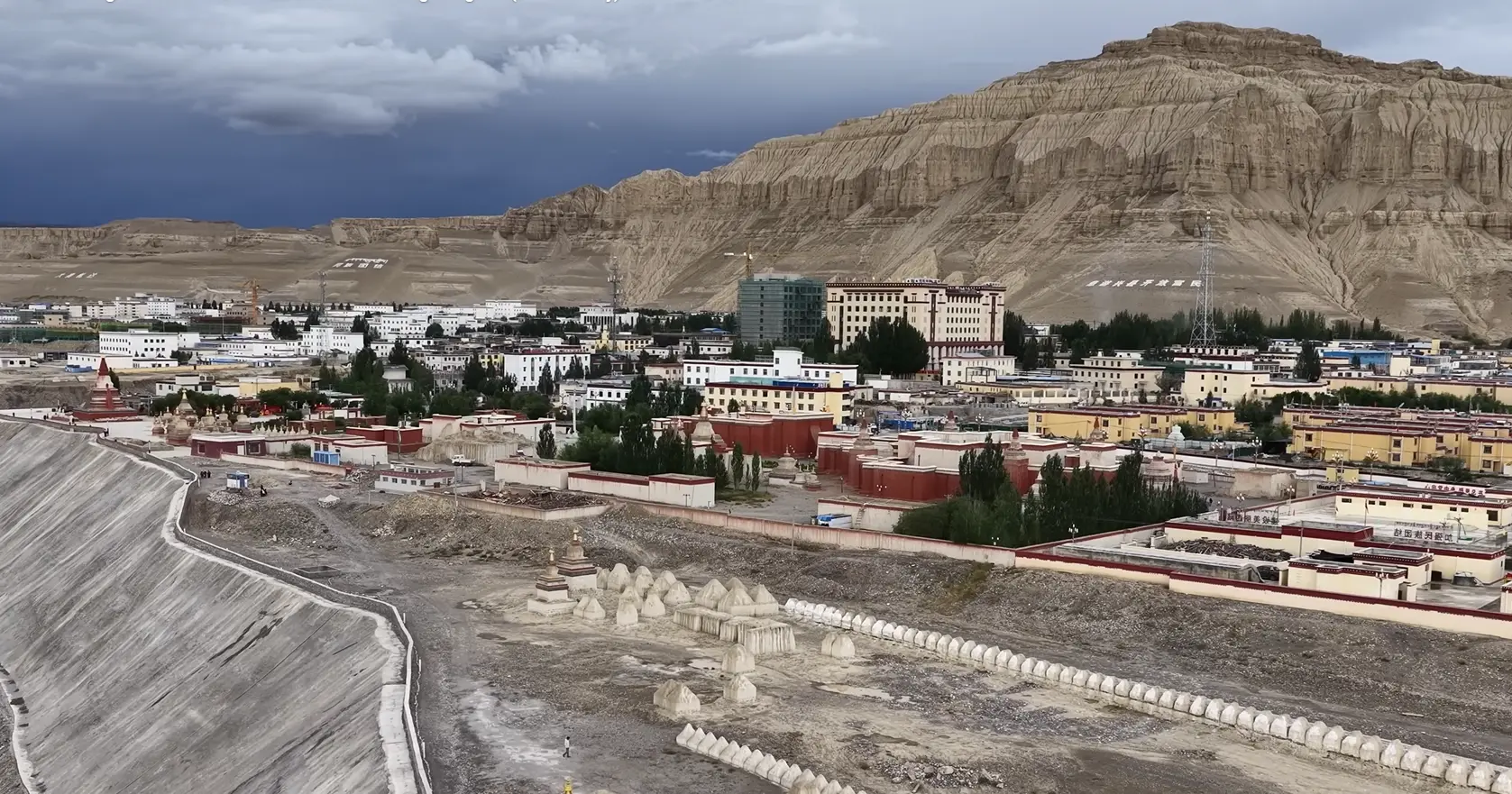
The lost city of the Guge kingdom lies in Zanda County of Ngari in western Tibet. The kingdom lies at an altitude of 3,735 to 4,000 meters. The Tibetan region is always hit by the high speed wind, shaping the morphology. The land is cold and dry like a desert.
Surviving in the high altitude desert is difficult and sounds like a story from mythological land. The structure, morphology, and terrain of the Tsaparang look unreal. The towers made up of soil and clay stand like high towers, the deep canyons cut through the heart of the earth, and the landscape feels untouched by time.
The Rise of the Guge Kingdom
After the downfall of the Tibetan empire, the Guge Kingdom was founded in the 10th century. after the fall of the Tibetan Empire. A royal descendant moved west into Ngari and established a new kingdom at the edge of the Tibetan world.
The kingdom served as a hub for flourishing Buddhism, art, trade, and culture. Known for the most artistic walls, bells, sacred carvings, and monasteries, it was one of the most developed civilizations in the Himalaya.
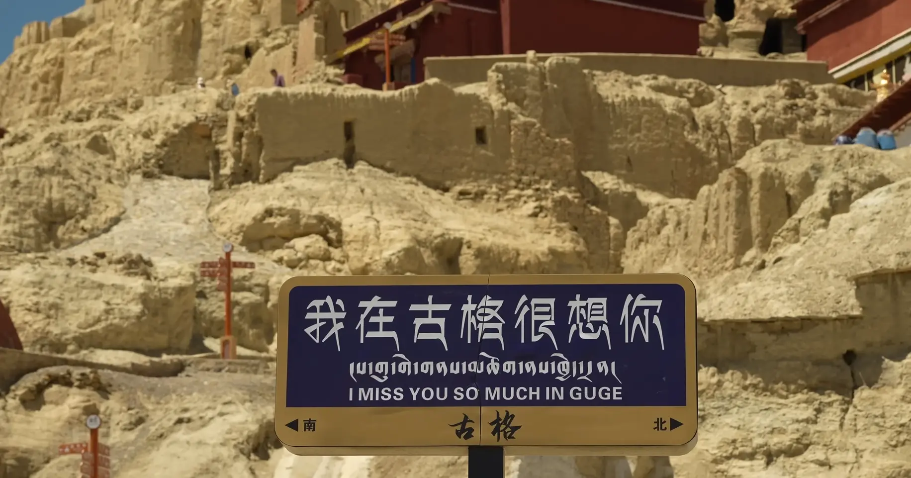
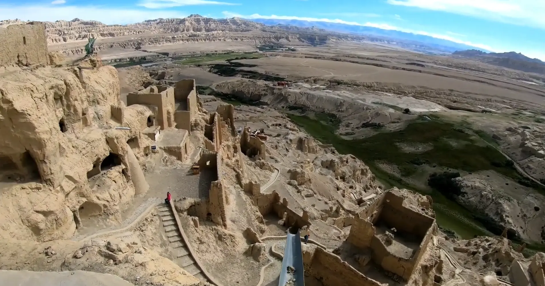
Tsaparang Ruins
Driving 200km from Darchen, one reaches the most scenic and mysterious routes of the Kailash journey to Tsaparang. This route is often included during the visit to Kailash and Mansarovar. The Tsaparang is visited as a day tour from Darchen, where the curvy road takes you through canyon edges, wildlife zones, and the famous clay forest formations.
Tholing Monastery: The Spiritual Heart Before Tsaparang
Before reaching the Tsaparang ruins of the Guge Kingdom, spiritual pilgrims often take a break to visit the Tholing Monastery. The monasteries in Tholing are often called the spiritual heart of western Tibet. Spiritual seekers prefer combining Tholing Monastery and Tsaparang in one day, making it a deeply meaningful journey. The monasteries of Tholing, which were founded in the 10th century, played a significant role in reviving Buddhism in Tibet, after Buddhism had nearly disappeared during the reign of King Lang Dharma.
There are 108 stupas, ancient temples, rich in Kashmiri style architecture, and mudstone structures that still carry an antique, sacred feeling within the monastic complex. Walking in quiet courtyards, scholar residences, and soft wind moving through prayer spaces feels like stepping back centuries ago.
Zanda Clay Forest
The journey from Tholing to Tsaparang passes through Zanda, a natural mystery of Clay Forest, shaped by high wind and water over millions of years. The yellow, red, and blue tones of the clay formation create a surreal terrain that looks like a dreamland for many pilgrims, new to the Tibetan land.
The Zanda region is often included in the day tour on the way to the Tsaparang caves. This is a wide region covering thousands of square kilometers. The trace of ancient human settlement can be seen on the rock ceilings, covered with smoke reminiscent of the life once lived in the caves.
Tsaparang: The Beautiful Village
Just below the Palace ruins, lies a small settlement of Tsaparang village, known for the homely accommodation where you can share the food with the local Tibetan family. The people here are believed to be descendants of Ladakhi soldiers and ancient Guge inhabitants, which explains their mixed dialect and culture.
Pilgrims must get a smaller eco bus from the village to reach the ruin. After driving 2 km, you reach the fort, with the scenery of cliffs, caves, giant fortress walls, and the river Sutlej. This is the reason why many Kailash pilgrims like to visit the Tsaparang ruins during the Kailash Mansarovar Yatra.
The Rise of the Guge Kingdom
After the downfall of the Tibetan empire, the Guge Kingdom was founded in the 10th century, after the fall of the Tibetan Empire. A royal descendant moved west into Ngari and established a new kingdom at the edge of the Tibetan world.
The kingdom served as a hub for flourishing Buddhism, art, trade, and culture. Known for the most artistic walls, bells, sacred carvings, and monasteries, it was one of the most developed civilizations in the Himalaya.
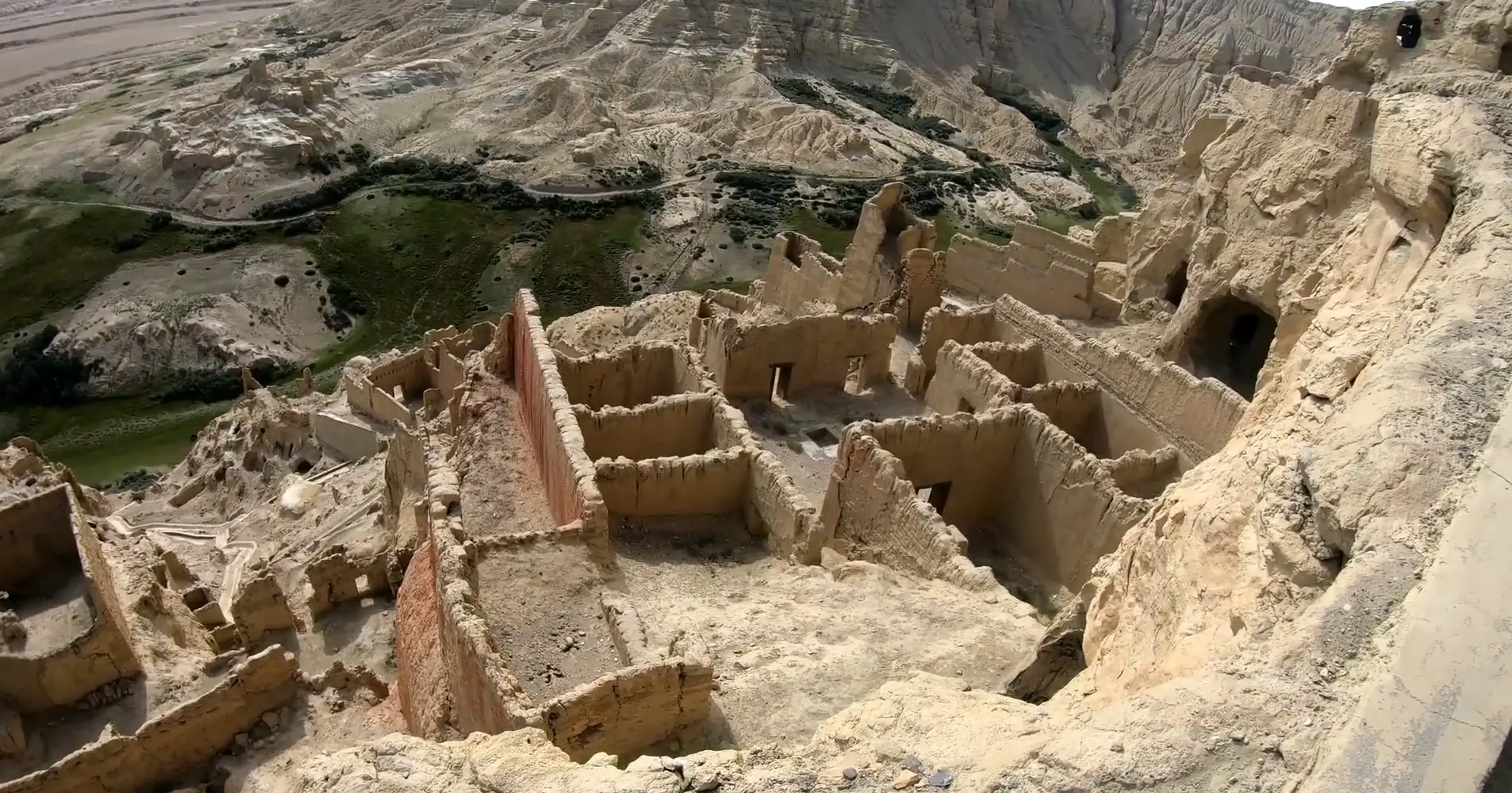
The Mysterious Fall of Guge
Once a stronger civilization, suddenly vanished, we mean people, with no trace of the exact reason. Historians say that it was an internal betrayal rather than an attack from outside. Around 1630, the royal family underwent family tension regarding religion. The king resisted rising Buddhist influence, due to which his brother allied with the Ladakhi Army, attacking Guge.
They say that the king surrendered after a long struggle, without choosing violence to save his kingdom and people. The massive wall still stands there, singing the song of the sacrifice and downfall. Archaeological discoveries have indicated some tunnel networks, but no exact answer is available about the people.
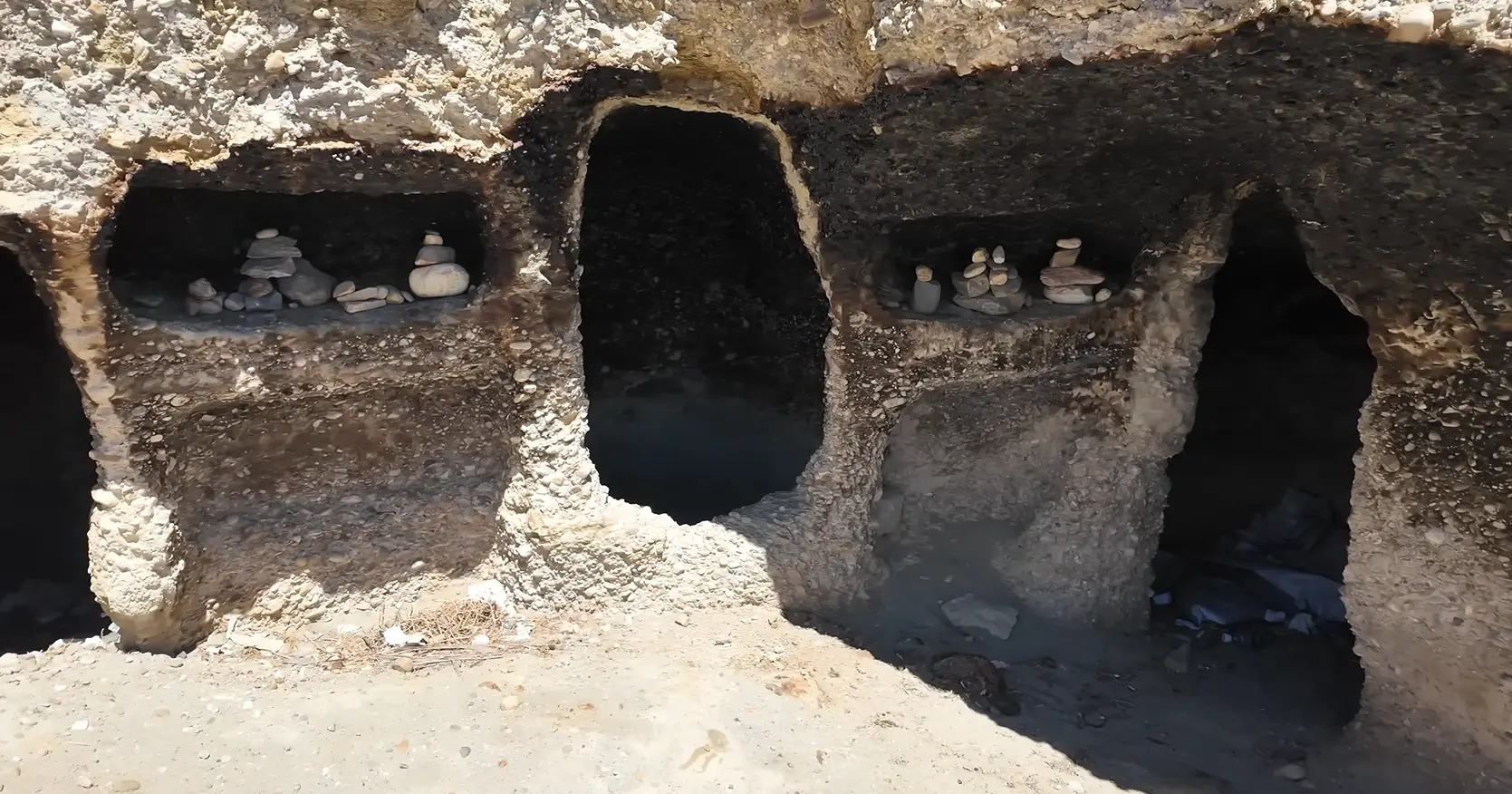
Burial Caves and Dark Stories
This is another interesting site in the kingdom. Below the ruins are caves, with preserved bodies of the dead. Is it those pwople choosed mass sacrifice rather than being surrendered? The area is restricted as the air inside is toxic now.
Tsaparang Viewpoints
This is one of the popular spots among photographers in Ngari. From the top of Tsaparang, the scenic view is amazing. You can see the clay forest towers, canyon valleys, and Himalayan ranges stretching beyond sight. The ruins of the fortress and cave openings on the hills create dramatic scenery.
Altitude, Safety, and Acclimatization Tips
The kingdom of Guge lies at a high altitude with thin air and cold temperatures. Proper acclamatization is necessary for visiting the caves. Move slowly and stay hydrated, and spend acclimatization days in Darchen. Note that the town gets active only after 9 AM. So, no need to hustle early in the morning.
A Mystery Hidden in the History
Visiting the Guge kingdom tells us that nothing in this physical world is permanent. GugeKingdom, once a powerful kingdom with rich culture, people, and religion, is now nothing but ruins. The entire kingdom collapsed, people vaanished but still the caves and archeological remains tell us the mystery that still breathes in the desert winds of Ngari.
FAQs
Expand AllWhat is the Guge Kingdom and why is it historically important?
Guge Kingdom was an ancient kingdom in Tibet, believed to be established in 10th century , after the Tibetan empire fell down. It was the largest kingdom then with advance art, Buddhism, and trade in the western Tibet. But, now, only the remains of the kingdom is found.
Where is Tsaparang located in Western Tibet?
Tsaparang is located in Zanda Valley of Ngari Prefecture. It is a dry and cold place popular for the ruins of the Guge Kingdom. It is about 200km away from the Mount Kailash.
Can Tsaparang be visited during Kailash Mansarovar Yatra?
Yes, Tsaparang can be added as an extra exploration in the itinerary visiting the Guge Kingdom.
How far is Tsaparang from Mount Kailash?
Tsaparang is around 200 km from Darchen taking 5–7 hours to drive.
What is the history behind the rise and fall of Guge Kingdom?
Guge was founded in 10th century after the fall of the Tibetan empire. The kingdom was abandoned in 17b the century with the exact cause still unknown.
What are the main ruins to see at Tsaparang Fortress?
The main ruins of the Tsaparang Fortress include the large wall, cliff caves, cave network, meditation rooms, temples, tunnels with murals, and the top summit view.
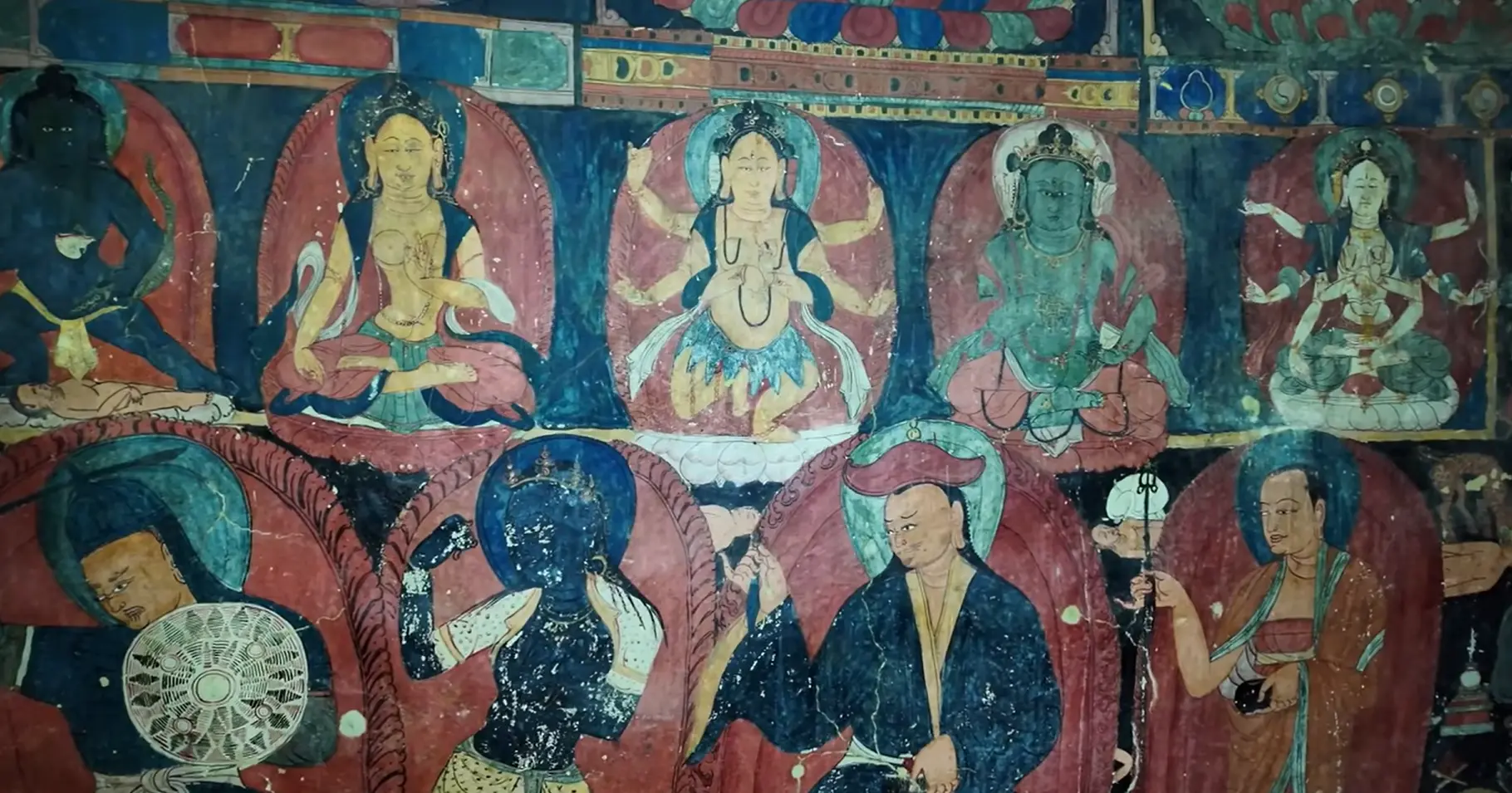
What are the Red Temple and White Temple?
Marpo Lhakhang is the Red Temple and Karpo Lhakhang is the White Temple, in the Tsaparang region. They are known for old Buddhist wall paintings and sacred art, where photoigraphy is forbidden.
Why are Tsaparang murals unique?
Tsaparang murals are very old and shows early Tibetan Buddhist art mixed with Kashmiri and Indian influence.
How much time is needed to explore Tsaparang ruins properly?
It takes around 2 to 4 hours, to walk to the top of the fortress. Exploring the caves might need more time.
What is the altitude of Tsaparang and Zanda Valley?
Tsaparang is situated at around 3,735 m and Zanda Valley goes near 4,000 m.
Is the climb to Tsaparang difficult?
The climbing is not very technical but the stairs are steep, narrow and tiring.
Is Tsaparang suitable for senior travelers?
Slow walkers and fit elderly people can reach the top with precaution.
What is the best season to visit Tsaparang ruins?
The best time to visit Tsaparang ruins are May to September during Mansarovar Kailash Yatra.
What is the best time of day for photography?
Morning and late afternoon, during the golden hour can give a better light for the photos. Mid day sunlight can be too strong.
Are photography allowed inside temples?
Many temples and monasteries do not allow to take the photographs inside. Always seek for signs or ask locals and guide.
Related blog posts
Discover a choice of tourist destinations loved by most of our visitors. Whether you're on a jungle safari to spot rare animals or walking through a world heritage site, these well-planned itineraries cover the major highlights of Nepal.


